Directions to the IMDEA Software Institute
The coordinates of the IMDEA Software Institute are
40.407091° North ; -3.835262° West.
There is parking available for visitors.
By car / taxi from the airport
- Take the M-40 ring road towards the A-6 / A-5 freeway (couter-clockwise).
- Take exit 38 and follow the service road parallel to the M-40.
- Then take the second exit on the right (opposite the tunnel under the M-40),
following the “UPM Montegancedo Campus” signs.
- Enter the campus and take the second exit in the first roundabout
(the first exit is a cul-de-sac).
After leaving the roundabout, the IMDEA Software Institute building is
the third one on the left side of the road.
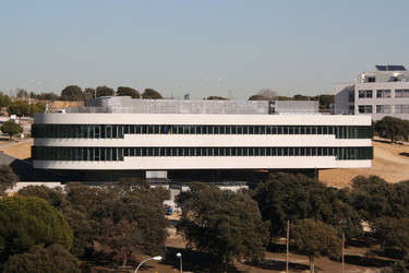
It is easy to distinguish because it has round corners and a triangular shape.
The following map
can help you (or the taxi driver) reach the IMDEA Software Institute building.
By car / taxi from central Madrid
- Take the A-6 freeway.
- Take the M-40 towards A-5.
- Take exit 38 and follow the service road parallel to the M-40.
- Then take the second exit on the right (opposite the short tunnel under the M-40),
following the “UPM Montegancedo Campus” signs.
- Enter the campus and take the second exit in the first roundabout
(the first exit is a cul-de-sac).
After leaving the roundabout, the IMDEA Software Institute building is
the third one on the left side of the road. It is easy to distinguish
because it has round corners and a triangular shape.
The following map
can help you (or the taxi driver) reach the IMDEA Software Institute building.
By car / taxi from the hotels in the nearby “Ciudad de la Imagen” or if coming using freeway A-5 via “Campamento”
- Take the M-511 road towards Boadilla del Monte and
take the exit marked “San Pablo C.E.U. / Ventorro del Cano / Urb. Monteprincipe”.
- Continue following the signs “San Pablo C.E.U. / urb. Montepríncipe / Ventorro del Cano”.
They will lead you to go to the rightmost lane and
take a ramp on the right until you reach a roundabout elevated over the level of the freeway.
- Turn around the roundabout until you face in the opposite
direction to the one you took to enter the roundabout.
The exit is marked “M-511 Madrid / M-40 / A-6 A Coruña” and is a ramp going down.
- Join the freeway again and after a short tunnel take the first ramp on the right,
which is marked “M-40 / A-6 A Coruña / M-607 / …”.
It will bend to the right and go up 3/4 of a circle.
- Continue on the rightmost lane and follow the signs
“Via de servicio / Monteleón / PCMASACOM / U.P.M. campus Montegancedo.”
Continue straight and you will see a sign “U.P.M. Campus Montegancedo”
which leads you to a tunnel under the M-40 freeway.
- Cross the tunnel to the other side of the freeway and in front
of you you will see the entrance to the campus; enter the campus.
- In the first roundabout, take the second exit (the first exit is a cul-de-sac).
The IMDEA Software Institute is the third building on the left after leaving the roundabout.
The following map
can help you (or the taxi driver) reach the IMDEA Software Institute building.
Public transportation
This map
has the subway / light rail / train networks.
Subway/LightRail:
-
Take the subway until the “Colonia Jardín” station in line 10 (dark blue).
Switch to ML3 (light railway line) and take it towards “Puerta de Boadilla”
(the only possible direction).
Stop at the “Montepríncipe” station and exit the station to “Avenida de Montepríncipe”.
Turn right and follow “Avenida de Montepríncipe,” past “CEU,” to the
“Escuela Superior de Ingenieros Informáticos” or “Facultad de Informática”
(School of Computer Science) sign.
You will recognize it as you will see two large buildings with a green glass façade.
Enter the campus through the School of Computer Science and continue to
the IMDEA Software Institute building on the other side of the campus.
It is 15 to 20 minutes walking from the subway station.
You can download Subway and LightRail maps from
this page.
Buses to the Montegancedo Campus (stopping in front of the
IMDEA Software Institute building – stop name “Centro de Empresas”):
- Line 591: Take it in front of Aluche metro station.
You can pay directly to the bus driver. The stops and schedule are:
- Line 865: Take it in Paseo de Ruperto Chapí
(close to Moncloa metro station). The stops and schedule are:
Buses to the Montegancedo Campus
stopping in “Avenida Montepríncipe” street.
You have to enter the campus and then walk across it until the IMDEA Software building:
- Line 573: Take it in Paseo de Ruperto Chapí
(close to Moncloa metro station) or in Paseo de la Florida
(close to Príncipe Pío metro and train station).
The stops and schedule are:
- Line 571: Take it in front of Aluche metro station.
The stops and schedule are:
- If you are staying in Boadilla:
either take the light railway line ML3 to the Monteprincipe station
(see directions from there above) or take line 566 in one of its stops.
The stops and schedule are:
By bike
The ride is approximately 45 min from the city center and is of moderate difficulty.
Enlarge the map.
Campus map
The following is a Google maps view of the
Montegancedo Science and Technology Park:
View Larger Map
Photograph of the building